One county’s history
The Legal Genealogist begins the 2018 lecture season on Saturday, February 24, at the Pinellas Genealogy Society’s 2018 Seminar in Largo, Florida.
Oh, my.
Florida.
In February.
For someone who lives in the mid-Atlantic states where we had five inches of snow Saturday night.
Hey… it’s a tough job, but somebody has to do it.
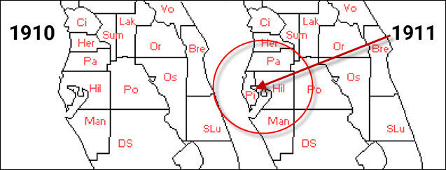
So as I get ready for the seminar, I’m doing my usual poking around in materials and resources of the area, and for Pinellas County, Florida, that turns out to be a little more difficult than you might expect.
Because there wasn’t anything called Pinellas County in Florida until the 14th of November, 1911.
That’s when Pinellas County was created, from Hillsborough County.1
The law set the county boundaries,2 made Clearwater the county seat,3 and required newly-appointed officials to meet for the first time in January 1912 to get things organized.4
So if you’re looking for genealogical records for somebody in Clearwater before then, you’re generally not going to find them in Pinellas County unless something happened after 1911 to require an additional action of some kind in the new county.
Which means, of course, you’d look in the records of the parent county, Hillsborough.
Now we know it’s the parent county because of the very first words of the statute: “That the County of Pinellas be, and the same is hereby created and established. Such county shall comprise and include all that territory of the County of Hillsborough…” and then the county lines are drawn.5
That was easy, right?
Except that you now need to know when Hillsborough was created. And how many times its boundaries changed, since that might impact your folks. (It was created in 1834, by the way, and had 11 boundary line changes — included one more involving Pinellas County in 1939.6)
Now we’ve talked in recent weeks about some of the tools for this, with one of the very best being the Atlas of Historical County Boundaries from the Dr. William M. Scholl Center for American History and Culture at The Newberry Library in Chicago.7 Online. Free. It doesn’t get much better than that.
Except — you knew there was gonna be an except, right? — when you can’t get an internet connection, or the site is down for maintenance, you’re sitting there at 3 a.m. in your bunny slippers, you need the information, and you need it now.
Now what?
That’s why I own a program called AniMap.
It’s a Windows-only program that I frankly couldn’t live without. It’s not free, it’s not even cheap (it’s $71.95 to download and $84.95 if you want it shipped on a CD), but to me it’s worth every penny.
Available from The Gold Bug (the website of its developers), the program is described this way:
This program will display over 2,300 maps to show the changing county boundaries for each of the 48 adjacent United States for every year since colonial times. The earliest map shows Virginia boundaries in 1617. Other states and territories begin with the earliest boundaries established. AniMap includes all years in which there were boundary changes, not just the census years. Maps may be viewed individually, or the program can set them in motion so you can view the boundary changes in a movie like mode. Maps showing the full U.S. are also included showing all the changes in state and territorial boundaries from 1776 to the present.8
That by itself would be reason to own the program. The image above, showing the counties in 1910 and 1911, was created from AniMap images. But there’s more. It also lets you check the locations of places that may no longer exist, in a database called Sitefinder. Want to know where the planned but no longer existing Aladdin City, Florida, was located? It’s there in the database.
As you can see above, AniMap isn’t pretty. It doesn’t have a lot of bells and whistles. It’s definitely not the easiest program in the world to learn or to use.
But what it does, it does as well as or better than any tool around — and you don’t have to have an internet connection to use it.
Just a Windows computer, running anything from Windows 98 to Windows 10.
Check it out.
SOURCES
- AN ACT, Providing for the Creation of Pinellas County, in the State of Florida, and for the Organization and Government Thereof, chapter 6247, Acts and Resolutions Adopted by the Legislature of Florida… 1911 (Tallahassee : T.J. Appleyard, State Printer, 1911), 219; digital images, HathiTrust Digital Library (http://www.hathitrust.org/ : accessed 18 Feb 2018). ↩
- Ibid., §1. ↩
- Ibid., §3. ↩
- Ibid., §§5-6. ↩
- Ibid., §1. ↩
- See “Florida: Individual County Chronologies,” Florida Atlas of Historical County Boundaries, The Newberry Library (http://publications.newberry.org/ahcbp/index.html : accessed 18 Feb 2018). ↩
- Judy G. Russell, “Finding those county line changes,” The Legal Genealogist, posted 5 Feb 2018(https://www.legalgenealogist.com/blog : accessed 18 Feb 2018). ↩
- AniMap: Find Old Towns & Counties, The Gold Bug (https://goldbug.com/ : accessed 18 Feb 2018). ↩


I couldn’t agree more. It is an essential aid for any extensive research – especially if you are researching the 18th & 17th centuries in the US and if you are researching multiple state. Excellent program.
what about us Apple iMac users? Anything similar to Animap? A web based tool? I tend to rely on the Interactive map often listed on the FamilySearch County Wiki page. Others have recommended something called RandyMajors but I haven’t got the hang of that one.
The best web-based tool is the Atlas of Historical County Boundaries from The Newberry Library in Chicago referenced in the post.
Judy, I, too, have been using AniMap for a long time. I’ve obtained permission from the author to use the images in client reports, too. Of course I have to use GIMP to clean them up a little, but it’s great to be able to show boundary changes. Couldn’t work without it!
Judy,
I have used AniMap for a decade in conjunction with a genealogical software program without problems and it has been an important tool over that time for those niggly county changes. My most recent purchase of AniMap has sadly been a downer. Even with the kind help of Mark Lassagne from Goldbug this version will not operate properly. Continual “File Load” error keeps occuring even with my IT Tech son attempting to get program running. It appears there were problems a few years back with another version that still seems to crop up now. I am pleased that “Atlas of Historical County Boundaries” is available online and for free as the loss of almost $100 CDN for a non-functioning program is something my limited funds cannot afford again.
That’s really a shame, Sam. Sorry you’re having issues with it.
What a valuable tool for research in our history. Thanks, I had never heard of it!
Glad you found the post useful, Stan!
As a 5th generation native Floridian, I like to remind people and especially those of us in south Florida, that, except for Alaska, Florida is the last frontier. We are not that far from its pioneer days!
I’m sure there are parts of the country that would dispute the penultimate frontier claim, but … 🙂