More copyright-free images
Like many with an abiding interest in history, The Legal Genealogist has been riveted by the new Ken Burns documentary, The Dust Bowl, which is showing in two two-hour episodes on Public Broadcasting System stations around the country. If you’ve missed this amazing production, it’s available for viewing online: Episode 1: The Great Plow-Up and Episode 2: Reaping the Whirlwind are both going to be online at PBS Video until December 4th.
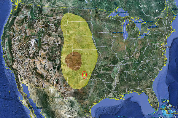
The story is powerfully told, in words and images, of the drought of the 1930s in the Great Plains of the United States, when huge dust storms rolled over hundreds of miles of territory. The area hit the hardest, the area called the Dust Bowl, was about 100 million acres in the Texas and Oklahoma panhandles and areas of nearby Colorado, Kansas and New Mexico. Overall, the dust storms affected a huge swath of land running from the Dakotas and Montana in the north to central Texas in the south.1
I had to map it out to be able to see it for myself (dust bowl area in brown, area affected by dust storms in yellow):

And, as you can see, I had to mark one particular location, circled in red. It’s Frederick, Oklahoma, where my great grandmother Eula (Baird) Robertson, her Livingston half-siblings and so many of my Livingston cousins lived throughout the 1930s.
And, in particular, it’s where my grandmother’s cousin, Thelma (Livingston) Dibble, lived and endured the storms of spring… and the dust storms of the 1930s. Where, she recalled when I visited with her this past May, they used wet towels to breathe through as the dust rolled through town. Where they woke up in the morning with gritty dust on the chenille bedspreads and in everyone’s mouths. Where they wondered sometimes if they were going to wake up at all.2
So the story of that terrible time is, in part, the story of my family too. It’s the story of many of our families.
And what’s truly wonderful is the fact that so many of those powerful images used by Burns in his documentary are equally, readily, freely available to each and every one of us as genealogists, to explain and illustrate what our own families experienced and endured.
That’s because so many of the most iconic images of the era were taken by photographers employed by the Farm Security Administration, a New Deal agency in the U.S. Department of Agriculture: Dorothea Lange, Arthur Rothstein, Walker Evans and more.3 And because the images were made by employees of the United States Government in the course of their official duties, they fall under 17 U.S.C. § 105, the section of the U.S. Copyright Act that provides that “Copyright protection under this title is not available for any work of the United States Government.”
Large numbers of these images, free from copyright restrictions, are available online in the digital collections of the Library of Congress. The Prints and Photographs Division has collections of black-and-white photographs and color photographs from the Farm Security Administration in its American Memory project. What follows is just the smallest sampling… and even just these few are enough to make a genealogist’s heart rejoice:

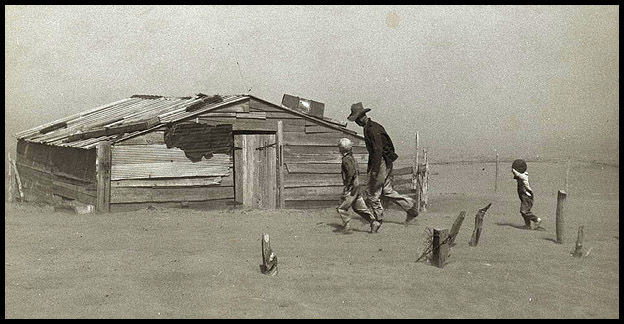
Farmer and sons walking in the face of a dust storm, Cimarron County, Oklahoma,April 1936, Arthur Rothstein, photographer4

Removing drifts of soil which block the highways near Guymon, Oklahoma,1936, Arthur Rothstein, photographer5

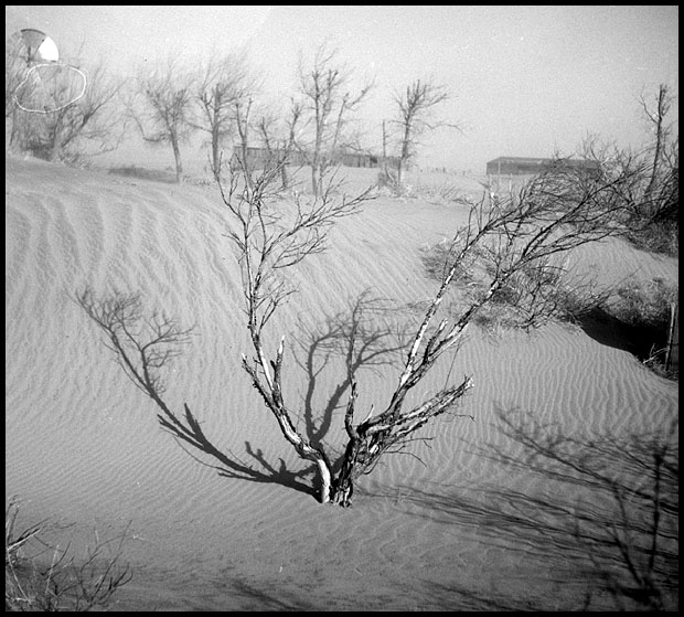
Orchard destroyed by drifting sand. Cimarron County, Oklahoma,1936, Arthur Rothstein, photographer6

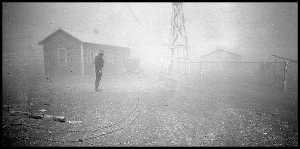
Dust storm,1935, Dorothea Lange, photographer7

Results of a dust storm. Cimarron County, Oklahoma,April 1936, Arthur Rothstein, photographer8
SOURCES
- Wikipedia (http://www.wikipedia.com), “Dust Bowl,” rev. 20 Nov 2012. ↩
- Judy G. Russell, “The storms of spring,” The Legal Genealogist, posted 16 May 2012 (https://www.legalgenealogist.com/blog : accessed 20 Nov 2012). ↩
- Wikipedia (http://www.wikipedia.com), “Farm Security Administration,” rev. 20 Nov 2012. ↩
- Arthur Rothstein, photographer, “Farmer and sons walking in the face of a dust storm, Cimarron County, Oklahoma;” Prints and Photographs Division, Library of Congress (http://www.loc.gov : accessed 20 Nov 2012). ↩
- Ibid., “Removing drifts of soil which block the highways near Guymon, Oklahoma.” ↩
- Ibid., “Orchard destroyed by drifting sand. Cimarron County, Oklahoma.” ↩
- Dorothea Lange, photographer, “Dust storm;” Prints and Photographs Division, Library of Congress (http://www.loc.gov : accessed 20 Nov 2012). ↩
- Arthur Rothstein, photographer, “Results of a dust storm. Cimarron County, Oklahoma;” Prints and Photographs Division, Library of Congress (http://www.loc.gov : accessed 20 Nov 2012). ↩


Great article. This its probably a silly question, but do you know if state agencies took similar type and if the same rule applies?
I’m sure there were some state agencies that did their own photographic studies, but no… the copyright exception for government works applies only to federal government employees.
ARe these image straight out of ohio
Oklahoma, not Ohio.
Thank you for sharing the PBS episodes on The Dust Bowl. I watched the whole thing today and I learned a lot. I can definitely see history repeating itself not far in the future.
It really is a wonderful series… but oh yeah… it sure is possible to see the potential for other man-made disasters, isn’t it?
Wow! Never knew this part of the American Memory Project existed! So many possibilities… I’ve been looking at photos of homes in the small Illinois town where my great grandparents lived. Thank you for sharing this incredible resource.
Pamela Boyer Sayre, who lectures widely on the Library of Congress, calls it “our National Treasure.” I sometimes think she’s understating it, Lise — the goodies you can find just on the website (much less at the LOC in person) are astonishing.