Here’s one way to find it…
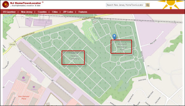
A genealogist across the country needed to know the physical proximity of two New Jersey cemeteries to try to understand how a burial in one cemetery got reported by a Find A Grave contributor as having been in the other — could it have been, she wondered, simply that the recorder had crossed from one to the other without knowing it?
That’s not an uncommon problem in genealogy — we need to know where the cemetery is, or what it’s near, or how to get there. Or where the school or canal or airport is.
And if we’re not local, we’re going need to ask.
Except, of course, sometimes there isn’t anybody — or isn’t anybody awake — that we can ask.
And then we’re stuck, right?
Nope.
Not in the United States, at least.
Because there’s a wonderful website that can tell us pretty much anything we’re going to need to know about the physical location of just about all of the sorts of places we might need to find.
It’s called the Geographic Names Information System (GNIS) and it’s a web offering of the U.S. Geological Survey (USGS). The website explains that:
The Geographic Names Information System (GNIS) is the Federal and national standard for geographic nomenclature. The U.S. Geological Survey developed the GNIS in support of the U.S. Board on Geographic Names as the official repository of domestic geographic names data, the official vehicle for geographic names use by all departments of the Federal Government, and the source for applying geographic names to Federal electronic and printed products.
The GNIS contains information about physical and cultural geographic features of all types in the United States, associated areas, and Antarctica, current and historical, but not including roads and highways. The database holds the Federally recognized name of each feature and defines the feature location by state, county, USGS topographic map, and geographic coordinates. Other attributes include names or spellings other than the official name, feature designations, feature classification, historical and descriptive information, and for some categories the geometric boundaries.
The database assigns a unique, permanent feature identifier, the Feature ID, as the only standard Federal key for accessing, integrating, or reconciling feature data from multiple data sets. The GNIS collects data from a broad program of partnerships with Federal, State, and local government agencies and other authorized contributors, and provides data to all levels of government, to the public, and to numerous applications through a web query site, web map and feature services, and file download services.1
Now USGS isn’t updating the information itself in the system anymore, but that doesn’t mean the system is getting outdated. Instead, there’s a crowdsourcing project called The National Map Corps that’s adding structures in all 50 States, Puerto Rico, and the U.S. Virgin Islands.2
So… you need to know about Restland Cemetery in Morris County, New Jersey, and where it is in relation to Gate of Heaven Cemetery? Here’s what you do:
1. Head over to the search page for the Geographic Names Information System (GNIS). The URL is https://geonames.usgs.gov/pls/gnispublic/.

2. In the Feature Name box, enter one of the cemetery names. In the example image, I entered Restland. Note that you can tick a box for Exact Match and another for Exclude Variants.
3. In the Feature Class dropdown box, choose Cemetery. (The options here are extensive — you could use this as well to search for an airport or a canal or a school.)
3. Use the State dropdown box to choose the state or territory where the feature is for which you want to search. I chose New Jersey here.
4. Once you choose the state, the dropdown box for the counties in that state will populate. I chose Morris for this search.
5. Click on the Send Query box.
The Feature Query Results page that appears tells me, among other things, that Restland Memorial Park, a cemetery in Morris County, NJ, is at latitude 404903N and longitude 0742207W. That’s fun. But the best part is if I click on the feature name. That takes me to a page with a Feature Detail Report, where I get an address and more.
Best of all, over at the right hand side of this detail report page, there are links to a number of different map services where which just a click of the mouse I can see a whole lot more about Restland Cemetery. I usually choose one of the three non-GNIS-type maps: the HomeTownLocator; ACME Mapper 2.0; or Microsoft Virtual Earth.
And choosing any of those, it’s pretty easy to see, isn’t it, how a burial in one might have been recorded in the other?

Pretty cool, huh?
So… when you really need to know where something is, or what it’s near, and there’s nobody to ask, ask the Geographic Names Information System (GNIS).
And hey… if you’re so inclined, join the The National Map Corps and add a structure or two to the system for the future.
SOURCES
- “Domestic Names,” United States Board on Geographic Names, U.S. Geological Survey (https://geonames.usgs.gov/domestic/ : accessed 3 Dec 2018). ↩
- See “The National Map Corps,” National Geospatial Program, U.S. Geological Survey (https://www.usgs.gov/ : accessed 3 Dec 2018). ↩


