For witnesses and jurors, a clue
Every document — every single document — in every single court file in every single repository — might tell a story.
Which is why The Legal Genealogist so often recommends getting court records, and milking them for everything they’re worth.
Case in point: the witness chits you will find in civil and criminal court files.
Here’s one example:

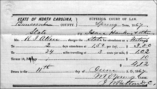
A man named R.J. Allen was a witness for the State of North Carolina in a case against Isaac Hawkins and others in the Spring term of the Superior Court in Buncombe County in 1867.1
Now the first thing we should all pay attention to was that R.J. Allen saw something involving Isaac Hawkins and others sometime before the spring of 1867. They had to have been in the same place at the same time when something happened that landed them all in court.
In other words, he was automatically in the Isaac Hawkins “FAN club”: friends, associates, neighbors. And we can expand that when we’re talking about witnesses: even enemies of the person we’re researching can lead us to critical clues.
So we would look for all the times and places when R.J. Allen and the Hawkins clan may have been together.
But we get another clue here. You see it, right?
It’s the fact that R.J. Allen was paid a mileage fee for attending: 34 miles at three cents a mile, or $1.02 in mileage, plus a 10-cent ferry ride.
So what does that tell us?
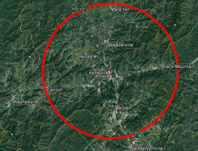
It tells us that R.J. Allen likely lived somewhere within this red circle:

That’s a 17-mile radius around the city of Asheville, county seat of Buncombe County, North Carolina.2
You see, in most states — and North Carolina was one — a witness like Allen would have been entitled to a fee for attending court. Jurors were usually also entitled to fees for attendance and for mileage. In this case, we can see that Allen was paid $1.50 a day, and he was entitled to mileage at three cents a mile. We don’t have to go looking for the statute that sets the rates, but if the rates weren’t there, we could have gone to the laws of the time and place to find out what they were.
He charged the State for his fees, so we know he testified for the prosecution and not the defense in this case, and his total mileage was 34 miles. That’s 17 miles each way.
Yes, it’s possible that it was 17 miles each day, but it’s not likely. A horse walks at an average speed of four miles an hour and trots at an average speed of 8-12 miles an hour,3 and there aren’t too many people in 1867 who could have spent four or five hours round trip each day for two days — more when you add in the ferry ride. So it’s much more likely that this was one trip in of 17 miles, and one trip out of 17 miles.
And the red circle shows what’s 17 miles away from the courthouse in Asheville.
It was produced using the Tools: Circle feature of Google Earth Pro — a free mapping program you can download, and yes, I did use a photo processing program to make the line a little easier to see here. And while it doesn’t tell us where along that circle we’re going to find R.J. Allen, it’ll help narrow down his location when we add it to the census and tax records and other documents we’d gather up.
Because every document — every single document — in every single court file in every single repository — might give us the clue we need to tell the story we want to tell.
SOURCES
- Buncombe County, North Carolina, Superior Court, Slave records 1861-1868, (broken series); digital images, “North Carolina, County Records, 1833-1970: Buncombe,” FamilySearch (https://familysearch.org : accessed 17 Nov 2016). ↩
- “About BC: A Brief History,” Buncombe County North Carolina (https://www.buncombecounty.org/ : accessed 17 Nov 2016). ↩
- “Horse: Equus ferus caballus,” Speed of Animals (http://www.speedofanimals.com/ : accessed 17 Nov 2016). ↩


Plus he would have lived on the other side of a water way from Asheville which was large/deep enough to require a ferry.
Yep, but that pretty much describes most of the county. 🙂
There is one assumption here though, that is that whatever happened that R.J. was witness to, happened at where he is now (at the time of the case).
Mr. Allen and Mr. Hawkins may have been at a third location. One either inside, or outside the circle.
Either way, it is a good starting point to find further records.
Nope, the assumption is not to where the event happened (which could have been anywhere within the jurisdiction of the court) but rather “that R.J. Allen likely lived somewhere within this red circle.”
Stand corrected. Thank you.
I assume the circle is determined by as the crow flies; therefore, traveling up and down hills and switchbacks would change the shape of the circle from Asheville. Wonder where the old roads were and if they still exist how they have been changed.
My circle is as the crow flies; whether the road distances were used, that would depend on local custom and usage.
In the 1870 US Federal Census, there is an R. J. Allen living in Mills River (just N.W. of Henderson). He is a well-to-do farmer with a large family. There were ferry operators at the time on the French Broad River leading into Ashville also. I Googled “french broad river ferry history” and got some good results.
You know you’re a genealogist when… 🙂
A little sidelight here. Black Mountain was once know by a name now considered derogatory! Glad they changed it.
I don’t deny your logic that this was most likely a single round trip. Were it critical toward determining his residence, though, I can see a few more questions that could send us running to the lawbooks for guidance:
1. There’s no bill for lodging. Would this normally have been paid? If so, this implies the possibilities (a) R J Allen made two trips, (b) R J Allen had friends or relatives to stay with in Asheville, or (c) R J Allen simply didn’t claim it.
2. Presumably the claim was for two 5-cent ferry rides, since it would have been necessary to use it in both directions (I really doubt they had one “free” direction the way we do today). But … if the claim were for a single fare, then perhaps the reimbursement was on a one-way basis, meaning the search area needs to be expanded by as much as 2724 square miles.
Sorry, that last bit was the math geek in me! At any rate, the point is simply to illustrate that, if what we learned from this receipt didn’t prove fruitful, we might just need to investigate the law a little bit more.
Looking at the law, mileage only, not mileage plus housing. Presumably, the witness fee was to account for any other costs. The law is fuzzy on the ferriage — it appears to be a flat rate, not an actual cost.
The terrain is very rugged with deep ravines between mountains. Many of the present day roads follow the old drovers’ roads which was the principal way of transporting goods into and out of Buncombe County. For example, the Old Buncombe Road extends into South Carolina through Greenville County, South Carolina, and is in use today.
That sounds like a description of most of western North Carolina (“very rugged with deep ravines between mountains”). 🙂
I lived in Buncombe County for 23 years and you can’t get anywhere in a straight line. So the 17 miles would have been road miles, correct?
Whether the road distances were used, or map distance, would depend on local custom and usage.
Great article. The comments especially point out that each of us can conclude how large to draw the 17 mile circle (as the crow flies, as the road curves) and which river the ferry crossed (good catch with the census record Mr. J. Paul Hawthorne 🙂 ). The latter may be enough to determine if the R. J. Allen on this witness chit is the one in that 1870 census record. Oh so much more can be discovered from this little piece of paper.
I live near here.